Showing posts with label touring. Show all posts

Sunday, March 05, 2017

Plotting the Summer starts the previous December- Glacier; Going to the Sun Highway

Riding the Going to the Sun Highway has been on my bucket list for many years. I wanted to hit it when I went down the Great Divide , but that was a missed opportunity. When I mentioned this to my partner, he agreed to go with me. My partner is a good cyclist, but not hardcore. The fact that he's interested in doing this truly thrills me.


I started the process by calling Glacier Cyclery in Whitefish, Montana. One of the employees, Vanessa, emailed me back with a lot of information. She suggested that I make sure I have bike rental reservations finished by mid-March. When I had the dates all confirmed and the airplane tickets, I called Glacier Cyclery. I actually got to speak to Vanessa, and she suggested altering my plans. My plan had been to start up as early as possible, believing that everybody had to be off the road by 11 o'clock and there were no other chances to go up. Vanessa noted that leaving early in the morning, it is cold and there's a lot of traffic that makes the trip up quite stressful. Adding to that stress is the time factor, requiring cyclists to be at the top before 11 o'clock. Vanessa also informed me that after 4 o'clock cyclists are allowed again on the road. She noted that it's a fabulous time to go up since the sun doesn't go down until 9:30 at night. She also stated that at 4 o'clock most of the traffic is coming down, and all the people who were rushing to go up to start hikes in the morning are gone. There was an added bonus on top of that; the alpine glow lends a beautiful hue to views on the way back home. We don't have to mention that I do not work for Glacier Cyclery... I was truly impressed by her knowledge of that particular road, and that she's done it several times. The bike rental situation is quite good, especially after I asked her for her advice in terms of timing. Also the rates are quite reasonable and they're going to rent us a bike rack for our rental car. I have had positive dealings with Glacier Cyclery previously, when I was on The Great Divide Route. They took a phone order while we were far away and very remote, for one of my companions who had panniers that failed. The panniers were waiting when we arrived in Whitefish, MT at Glacier Cyclery.

I am more excited to go than ever...

Wednesday, August 05, 2015

IHSMBR Idaho Hot Spring Bicycle Route Update

We postponed our trek due to physical and financial reasons, but hope to go next summer.  In the meantime, here is some info people might find interesting:

I bought a book called "Another Fork in the Trail", which is a collection of backpacking recipes to be prepared and dehydrated ahead of time.  The recipes were fun to cook and dehydrate with my cycling buddy, but for the most part they are really time consuming. My family recently tried one of the resulting meals on a camping trip and rated it only a 3 out of 4 stars. The rating is not high enough to warrant the prep time.  Some of the recipes could be made more quickly by using canned ingredients, such as canned sweet potatoes.

Sunday, February 01, 2015

Idaho Hot Springs Prep

Adventure Cycling announced a new mountain biking route, and this one is a doozy.  The climbs on the main route and the singletrack options are both tougher than the Great Divide Mountain Bike Route.
Washington Peak by wsiegmund cc by
Washington Peak by Wsiegmund CC BY
The main route has 4 climbs of close to or over 3,000 feet in 10 miles, the highest point being at 8,719 ft altitude, when traveling in the direction AC suggests. Of the singletrack options, Secesh has one ascent of this caliber and Willow Creek and White Cloud each have one,  and in both those last cases you lose 500ft, which need to be regained.
In comparison, looking at the GDMBR, north of Breckenridge and including the Canada section, I could only find one section with that kind of gain/loss (Galton Pass) and if you take the route in the southerly direction AC recommends, it is a downhill.
My cycling partner looked at many blog posts of people who did it in its first year of available maps and came to the conclusion that you can probably only do 20 miles a day, at least on the singletrack, and not much more on the main route.
The main route is a 517.6 mile loop out from Idaho City and includes a singletrack option from Boise, allowing easy airline access.  There is a shortcut across the middle back east, in case you need to bail. The singletrack options, by their very nature, are long and remote.

Monday, August 11, 2014

And on to Lake Champlain

A new trick (for me).  I drove to Lake Champlain at Port Kent, left my car there and took the ferry across. $9.  The crossing took 1 hour, during which I was free to read, look around and NOT drive. Pleasant. FYI there is also an Amtrak station in Port Kent, within walking distance of the ferry dock. Unfortunately the train is slated to take 10 hours to get there and it is only 6 to drive.  Given my previous report of Amtrak usually being an hour or more late, it was not appealing. But the FERRY! Highly appealing. The ferry is so large that you don't feel the swells and a bike doesn't need to be secured to keep it from falling over. So I packed all my panniers on the bike and off I went to Burlington, where I was to meet up with Jamie.

We stayed at North Beach campground, a Burlington park. This park does not have a "no turn away" policy for cyclists, paddlers or hikers, which is a bit of a travesty. When asked why not, the woman at the office exclaimed "If we are full, where would we put them?"  Answer; on the unused volleyball court. Really.  How many could there possibly be? I should write a letter... maybe tomorrow... We rode in to downtown Burlington to their fabulous Co-op to gather supplies. The easy thing about this route is that there are very good re-supply stores all along the way. We carried no stove for this trip. It is warm, neither of us drinks coffee and we usually bought a sandwich to eat for dinner at one of the numerous grocery stores. 
The Lake Champlain Bikeway map is a really good start, but the routing had many odd misdirections and mileage errors.  We should have kept better track of these and given them some feedback to correct the map, but we were ill equipt to do so.  Part of the problem is that the map is available in PDF only (no hard copy) and formatted at a really odd size for home printing, so it was difficult to keep in a map case.  Really, I do have no excuse for not making corrections right on the paper copy I had printed out.  It would help them to get the feedback. On the VT side, the bikeway is marked at regular intervals (though not necessarily intersections), but in NY it is marked as Bike Route 9, I believe. Other than those minor problems, the route is pleasant (but not the most direct- which is fine). Adding camping info would also be helpful.

The second night we stayed at Crown Point, a DEC campground. These DEC CG are staffed by really good, smart people, who are constantly thinking and analyzing.  The night before the ferry, I had stayed in a NY DEC CG and was looking to do some hiking, but wanted to get to the trailhead via bike, having driven for 6 hours. The attendant took the road surface, shoulders and type of trail into consideration and pointed me to a nice trail with great views.
Anyways, this time, the attendant knew the weather forecast and asked us if we wanted to pitch in the only available lean-to. No wet tents in the morning.  Sweet.  There was an amazing thunderstorm that night!
We spent the next night at Ausable Chasm (pronounced Aws-Able Chasm, with the Ch sounding like chicken).  Although this was a private campground, it was pretty nice.  You have to purchase a separate event ticket to travel on the Chasm trails and we didn't think it was worth it, considering we were there for such a short time.
The NY side of the lake is much hillier overall and the route we used was quite, shaded and heavily wooded.
My Bike Friday New World Tourist scored 11,000 miles. Kind of astonishing to me, though I have been watching the milestone approach for a while. Totally missed the 10,000 milestone. I think it occurred on a commuting day.

Plattsburg is working on being more bike friendly, but they have a ways to go. It is obvious they are working on a bike path that hugs the lake, but it is not yet complete.  All in all, I didn't feel harried going through the city, except at a construction zone, when I am sure the drivers also felt harried.  There were several bike tours we crossed paths with along the northern end of the lake, all inn to inn tours.
We crossed the mouth of the Riviere Richlieu, the outlet of Lake Champlain, at Rouses Point and could see the Canadian border crossing just down the road.


The bridge took us back into VT and we headed down to North Hero, hoping to camp at North Hero State Park, but the CG had been closed due to bad flooding a couple of years earlier. There was nothing else, public or private that we could find until way down on Grand Isle at Grand Isle State Park. Long day.  Our 50 mile day turned into an 80 or so mile day, but again, they found us a lean-to and again there was a thunderstorm during the night. That was pretty much the only rain we experienced (except another incredible, but short lived downpour when we had instant access to shelter).
Both the DEC and VT state CG hold a "no turn away" policy for hikers and cyclists. Nice job.

Last day: we left Grand Isle via the "bike ferry". We had some difficulty locating the beginning of the northern part of the causeway.


I had some weird idea that this was a pretty long jaunt, but it turned out that it was a tiny ferry ride to cross a gap in the old railroad causeway. The gap allows boats to move from one part of the lake to another.
Ignore the amateur finger in the photo- mind the gap. Really.  That is it. The dock on the other side is the ferry dock. I'm serious.

I understand the causeway was damaged by the same storm that took out the campground, but am unsure if there was a bridge previously. The ferry fee is by suggested donation; $10 (actually more that the Lake Champlain Port Kent to Burlington ferry, but I don't begrudge them the money). Then you travel along the rest of the causeway.  It was pretty heavily used by pedestrians and cyclists, but we were the only touring cyclists around. Lots of young kids.


We stayed at the North Beach campground again that night. All around a pretty decent place with a lovely beach.  We spent the next day renting paddleboards, which was way more upper arm work than I am used to.
Bike repair station with basic tools and a simple repair stand- on the Bikeway.  Very cool.

This finished our journey, which I had miscalculated the mileage for, leaving us 3 unused days.
 
We returned to Burlington and rode the 60 or so miles to Jamie's house and spent those extra days kayaking on Lake Champlain and camping at primitive paddling access only campsites.


Sunday, June 29, 2014

Easing into the first tour of summer

A friend has committed to cycling all of the Finger Lakes in NY and she is almost finished, Cayuga being one of the last. Her and another friend and I joined on the eastern shore of the lake, left our cars and circumnavigated the lake counter-clockwise.
The weather was beautiful, not too hot, not too cool and no rain. The total distance is just short of 100 miles, so we had decided to try to stay in Ithaca.
I contacted a Warmshowers host there, who agreed to host us for a night. This was a fantastic initial exposure to Warmshowers for both Linda and Patty.  The hosts were sweet, engaging, and provided an optimum intro into the WS concept. Patty actually hosted their next night's guests when she got back home.  WS is such a great idea and it has never failed to pair me with both great hosts and great guests.


A fun end to a fun ride; we all jumped off the dock and Patty's friend's house into the lake. It was a terrific way to get clean and cool off, though the neighbors may have had to avoid drinking the water for a while : )


Wednesday, May 08, 2013

Testing for Leakiness

Here we have a GooTube, purchased from EMS.
 
It contains Hot Sauce, an essential cooking element. Since it seems like a dicey thing to carry, testing it under pressure using a marble mortar and pestle seemed appropriate. Although if you squeeze it when empty, the air gets out/in, it shows no indication of leaking the hot sauce. It might not be trustworthy under the pressure changes experienced in the cargo hold of an airplane, so it will be placed in a ziplock pre-fight.

Tuesday, April 30, 2013

Glacier National Park and Logan Pass

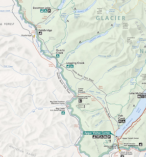
We were initially thinking about tackling the Going to the Sun Highway, which leads to Logan Pass.  Even though we probably are going to abandon this idea, due to time constraints, I thought I would post this.  I didn't find any information about cutting right to the Going to the Sun Highway from the GDMBR, so here is what I gleaned from a Glacier NP ranger.
GDMBR to Polebridge to Going to the Sun Highway
http://www.nps.gov/glac/index.htm
It is possible to continue down North Fork Road from the GDMBR.  The park service refers to this as the Outside North Fork Road, not to be confused with the Inside North Fork Road. The inside and outside refer to being inside or outside the park boundary.  This takes you into the town of Polebridge. When I asked him if it would be better to remain on the Outside or switch to the Inside, he concluded it would be better to stay on the Outside road, because it is much wider.  Both are dirt, the Outside taking more traffic. The disclaimer is that this ranger doesn't ride.  He noted that you might want a dust mask.
This route would probably take a day off route, as opposed to going all the way to Whitefish and then back into the park.
Anyone wanting to try this might consider calling the ranger station again for a second opinion on Outside versus Inside.  Either way, you end up at the south end of McDonald Lake, the start of the Going to the Sun.  The two campgrounds closest to the pass are Sprague Creek and Avalanche Creek, but I think he said the last place for food was at the Apgar Visitor center.  From one of the campgrounds, you could go up to the pass and back down. The distance from the breakoff to Polebridge, to Apgar visitor center and the top of Logan Pass, then backtracking and moving on to Whitefish is about 118 miles.  The straight GDMBR from the same breakoff directly to Whitefish is 49 miles and of course Logan Pass is all up, but not steep. If I interpret this document correctly, the grade does not exceed 6%.

Such excellent questions lately...

A couple of people have approached me lately asking about bicycles or bicycle travel.  This made me think about how to approach the answers and what resources are out there for people interested in starting out in cycling.

Question: I am interested in touring.  What kind of bike do I need?
Answer: This depends on what you can afford and are willing to put up with.  I know several people who rode really old (but originally high quality) bikes across the US.  The disadvantage is that anything with 27" wheels and a 5 cog rear hub will be more difficult to buy parts for.  In addition, the parts it has will probably be older and more worn, and more prone to breakdown.  Also, someone younger or with really sound knees might not care about the gearing, but those of us who are older generally need to be gentler on our knees, so the gearing becomes more important.  Get the best bike you can afford.  Apart from a dry tent, it is the single most important piece of equipment you will need.
Racing bike
ScottSpeedster, CC Flickr user Zacke82

Question: Should I buy a bike online or from a bike shop?
Answer: If you know a great deal about bikes, their components and what you want, you can probably get what you want online.  But if you are reading this post, I would think you are more my type: I want to ride a bike that will last and be comfortable.  I have bought both of my new bikes (as well as my very first used touring bikes) from bike shops. Don't bother with a chain store, if you can avoid it.  A local bike shop should try to sell you the bike you need, not something more. A local bike shop will rely on you being happy and coming back for accessories and tune ups.  Make sure you can answer some basic questions before you walk in.  A friend asked me what she should get and this is the list of questions I posed her:

  • What will it be used for?  Commuting? Recreation? Going really, really fast? (this will help determine how heavy a bike you can accept- the material it is made up of...)
  • Do you only ride in sunny, warm weather? (no need to worry about fenders if the bike won't be out in the rain- fenders require a frame that is wide enough to accept them, i.e. not racing bikes)
  • Will you carry things on it?  Just a repair kit or water bottles or a rack/bags? (This will help determine if the frame needs attachment points for those things)
  • How far do you expect to go on the bike?  Just a few miles or 30 miles in one instance? (this helps determine whether you will want to be more upright or more stretched out)
  • touring bike
    Surly LongHaulTrucker Touring Bike,
    CC Wikimedia Commons by insidestory
  • How tough is your butt?  Do bumps annoy you? (this will determine if wide or skinny tires  and suspension/springs are appropriate)
There are 3 main categories of bikes: racing, touring, mountain.
Racing bikes are light, with skinny tires and are not meant to carry things
Touring bikes have beefier tires and you can attach fenders, racks and other stuff
Mountain bikes lessen the bumps with wide tires, sit you more straight up and can often carry stuff
mountain bike
Cale, CC Flickr user k.streudel

*all generalizations are false (quote courtesy of my daughter)

Hybrid bikes are a mix of touring and mountain.  They sit you up higher, but tend to not have all the shock absolution of a mountain bike.

Generally bike shops are licensed to carry only a few brands.  Most likely there will be something in one of those brand's lineups that will make you happy.  If you are dead set on a specific brand, find a bike shop which carries that brand.  I preferred to answer the above questions and then take the answers to the bike shop.  I told them what I needed, gave them my max spending limit and let them dwell on it.  They go to shows and flip through catalogs all the time.  They know the components.

Oh.  One more thing.  Support your local bike shops.  You want them there when you need them, right? The price difference is usually less than 2%.  And there is a big difference between a Walmart inner tube and one from a bike shop.  Walmart tubes are only good for one thing, getting you to a real bike shop.  Well, maybe not even that.  Depends how far it is.

Saturday, April 27, 2013

Test of posting.

This is test of the android blogger app. The app worked well.  Not a lot of flash in the pan, but it allowed me the rudiments of blogging, including pulling in images from the photo gallery.

Wednesday, March 20, 2013

Banff Airporter

The Airporter is a shuttle service which travels between Banff and the Calgary airport.  The questions I asked them on the phone today:

Q- How many boxed bikes can one shuttle accommodate?
A- As many as there are passengers with boxed bikes. If there is not enough room in the shuttle, they send the bikes on the next shuttle to your doorstep. Shuttles run between 1-2 hours apart.

Q- How far in advance should we book a shuttle for a July 2nd airport arrival?
A- Mid-June should be fine

Saturday, March 16, 2013

More GDMBR planning- 3 months left


 The companions wanted ads finally did work.  Two gentlemen who need to start separately connected with me.  One wants to do the Canadian portion, but won't travel alone, a wise decision. To my great joy, a friend of mine has decided to jump into the fray.  My plane ticket has been bought.

Some thoughts on the McCoy book: I am not sure it is as important along the ride as the maps, but the truth will tell after I start. He offers great advice on first aid equipment and some details about other equipment. Maybe I will pull out the pages I want.
The Surly Troll now has racks front and back.  The Ortlieb panniers needed to have larger spacers exchanged (larger spacers came with them).  The diameter of the rear and front racks are different; no spacers are needed on the back. Both racks are Old Man Mountain Pioneers, I believe.
Here is a photo of the Surly almost fully loaded. Missing are the Teva sandals I just ordered and some small toiletries. The bags weigh 34lbs 10oz.

There is a shuttle from the Calgary airport to Banff and Canmore, so you can stay either place. As of this writing, the shuttle has extensive hours and takes 2.5 hours. We will probably stay at the YWCA hostel for 2 nights, which appears to cost $300 for 2 double beds w/out a private bath.  This would allow us to assemble and load our bikes under a roof, something which is not available if you use the campground in Banff.
To add to my equipment, I purchased a used Pategonia Down Sweater, which compresses very small and a pair of Teva Churn watershoes.  The watershoes are an attempt to replace my Keen sandals, which function really well, but take forever to dry and are heavy.  I will add an equipment review of them after they arrive and get a workout.
The fender problem still exists, but hopefully the local bike shop has some thoughts on this.  They are a pretty creative group.

Monday, January 07, 2013

GDMBR planning

I posted an ad for companions in both Adventure Cycling and CrazyGuyonaBike websites.  The responses have been far fewer than when I posted for the TransAm, but maybe that should not be surprising considering the two are vastly different.

Here are the steps so far:
  • buy the McCoy guide book
  • buy a mountain bike
  • buy the maps from AC
  • post the companions wanted ads on Crazyguyonabike and Adventurecycling
  • look in the forums for guidance on getting myself and my bike to Banff
  • look for a 800 fill used down jacket
  • look into how I will cover my shoes if it is cold or cool and raining
  • figure out how to attach a fender to my front fork (it has suspension and a rack attached)

The trail begins right in Banff, behind a hotel that has changed its name.  Currently it seems to be called The Fairmont Banff Springs. There is Canada Parks campground called Tunnel Mountain at the edge of Banff. They have two areas, one which seems to be full hookups and one with no hookups. In addition, many sites are first come, first serve and there are also a few walk in sites (probably last to fill).  For cyclists, the parks department notes that except for three day holidays, it should not be a problem arriving without a reservation (for those of us who have no idea when we will be arriving). I thought all Canadian campgrounds had a policy of "no refusal" for people arriving without a vehicle, but now am not so sure. BTW July 1 is Canada's Independence Day holiday.
As for getting from the Calgary airport, racers suggest that you take your bike with you on the plane and use Banff Airporter shuttle service to get to Canmore or Banff. Racers seem to glow with enthusiasm about this service.
The links I have collected about the GDMBR and related stuff is located here.

Saturday, October 20, 2012

Surley Troll

Thinking, planning, scheming.  The Great Divide Mountain Bike Route (GDMBR) is on my horizon and as such a new bike was in the equation.  My LBS, Campus Wheel Works, kept me in their sights for almost a year, looking out for a bike that would perform well in a wide variety of settings.  The GDMBR is comprised of single track (one lane dirt trail), double track (old roads), dirt roads and pavement.  Trying to find a bike to cover all aspects of this trail and carry panniers or tow a trailer is a challenge.
In late August, Ethan pointed me towards the Surley Troll, a hybrid/road/mountain bike which is able to morph into many different things, due to the multitude (ooooh- I've used that word twice today) of dropouts and braze-ons.  This configuration allows Rohloff hubs, which contain internal gearing to take the place of a derailleur, disk brakes, cantilever brakes, fenders and racks. Ethan poked around until he found a front suspension fork which could accomodate a rack (something mountain bikers would generally frown upon). I will miss using the really cool OEM fork, which has braze-ons for water bottle cages on the outer edges, along with braze-ons for anything else you can think of. The price tag comes to under $2,000, which is still a whole heck of a lot of money to me.
There is now a Thudbuster seat post on it and pedals which will accomodate Power Straps.  It seems like the Power Straps will outperform cages and give some of the advantages of clipless pedals without the special shoes. Addtionaly, it has a King water bottle cage and a new fangled Camelback bottle, which doesn't leak when turned on its side.
Now the bike just needs a rear rack and better reflectors and/or lights.  Here is a wonderful resource on tail-lights.  So sweet when someone does my homework for me and does it well.
 Oh, and when I asked about the dreaded "chain slap" which occurs when the derailleur can't absorb the slack caused by going over big bumbs, Ethan suggested a Cycle Stuff Chain Stay Wrap, which will probably be more durable than a cut up tube. I think the handlebars are Multibar Butterfly bars.  They should offer up a nice variety of hand positions for all the washboard road along the GDMBR.
I will be aiming for the summer of 2013, unless Adventure Cycling calls me to lead a tour, in which case I will gladly shift gears.

Review:
This is the first mountain bike type bike I have ever owned that was sized properly.  It rides smoothly, with the Thudbuster taking some of the jarring out of the rear without the weight of a full suspension. The fork (Rockshox) seems to offer a nice balance of absorption and has the ability to lock the suspension.
The rack is an Old Man Mountain and came with several options for mounting, but is designed for a suspension fork.  The disk brakes on this bike will help with the brutal braking conditions the bike will be subjected to, carrying a full load of panniers, water and me. Mud and water have affected every touring bike I have used, but this bike will see more mud than on a road tour, though not necessarily the downhill speeds seen on a road tour. I thought the tires would be too much for roads and not enough for of road- wrong: pretty good all around.

Two irritating things- the front derailleur cable comes out diagonally, impeding my ability to grab the bike and carry it by the seat tube up/down stairs and that same derailleur's clamp is placed between the two water bottle mounting points on the seat tube, necessitating the use of spacers (which it didn't come with) to attach a cage.

Monday, July 16, 2012

Netherlands July 16

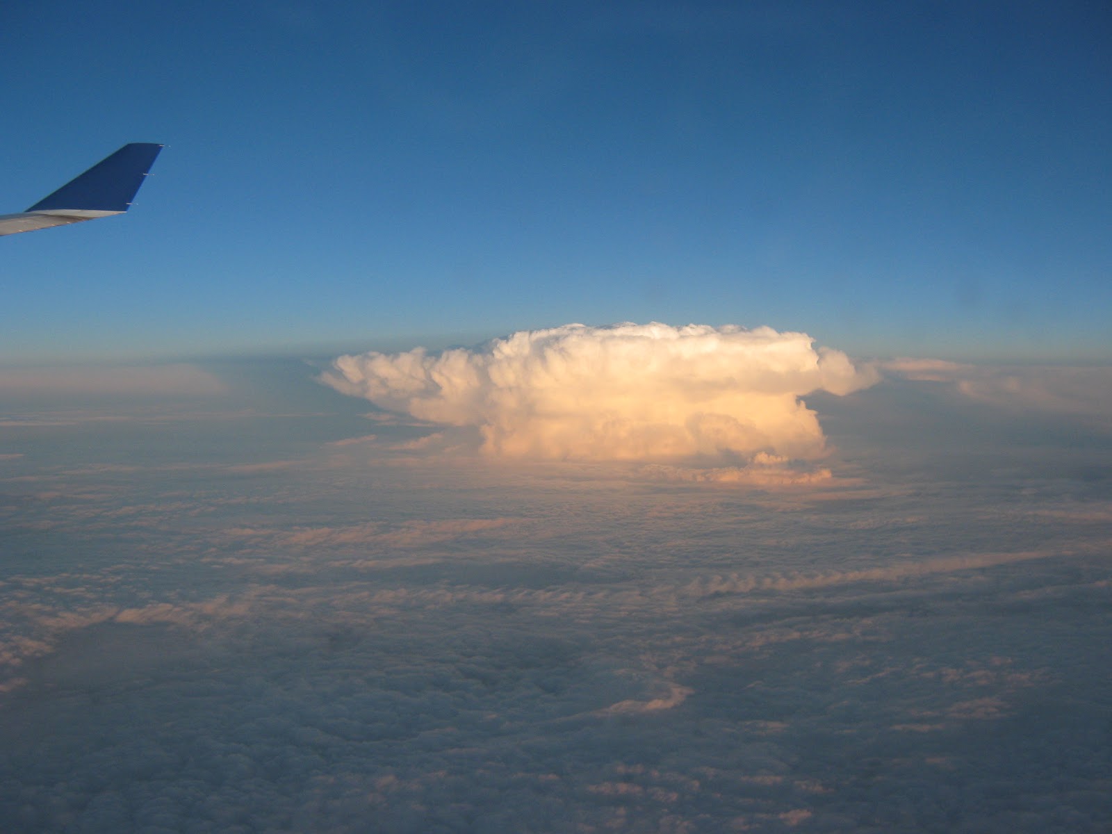
I left at around 5pm Buffalo time.  The flight is about 8 hrs, but travels back 6 time zones. This puts me in early the next day. Last night I deliberately slept for only 4 hours, so sleeping on the plane would be less difficult. I watched one movie and then slept a bit, on and off. This flight has many empty seats and the one next to me was empty, making sleep much more comfortable and likely.  We passed a huge thunderhead spewing lightning, which towered above the surrounding cloud bank but we were above and to the side of it.  For the most part there is a continuous carpet of clouds below us, with some beautiful thunderheads, which we were above.
thunderhead
 Windmills near Windsor, Ontario and again in France maybe, an oil rig off the coast of Holland. The clouds below us over the ocean were distinctly cotton candy pink, even though we were long past dawn.
Note the field of wind turbines off the coast.
 
Totally a land of water


Bill managed to find me right off and gave me my first lessons in cycling in the Netherlands. It started raining as soon as we left the airport and never stopped, though at least it was about 60 or 65 degrees.  There are roads where the two way car traffic gets only one lane and the cyclists get two.  And the cars have to wait if there is not room for all to pass. The drivers scare me sometimes, because they are forced to pass so close, but they are used to it and there is no maliciousness.  Flying overhead it had looked like there were pastures without fences, ditches serving that purpose and while cycling around, it was clear that the ditches are quite effective for that purpose. Arriving in Utecht was an eye opener, since the first sight you come across is the red light district. Little rooms perched on the edge of the canal, about two in a space equivalent to a shipping container, the women show their wares through picture windows with red neon down the sides. They all had on bras and underwear and weren't terribly risqué, but most were talking or looking at their phones. It is unclear whether they are engaged in sex chat or talking to friends or just surfing. Just a little further down the canal, beautiful canal/house boats line the edges.  We have seen several windmills already.  It appears there are only 900 left, but they are heavily protected.  It is supposed to be as difficult to run them as to pilot a ship. We arrived in Utrecht quite soaked and searched for the hostel and then a specific hotel, but finally gave up in exasperation and took a pretty pricy hotel. We dried our clothes on the heating registers successfully. Utech isn't especially lovely downtown, mostly owing to the massive railway station construction going on, the rest owing to the rain and grey. Thousands of bicycles are parked on every permissible surface.
On a separate note, Bill got 2 free pieces of luggage, though he only used one and brought his boxed bike for $50 via Icelandic air, while I only got one piece of checked luggage and had to pay $80 for my second piece (that being my bike in its suitcase). He may have gotten a better deal, depending on how much he paid for his ticket. He threw out his cardboard bike box and will buy another for the return trip (I think maybe he said he can buy it from the airline for about $25).

Saturday, August 13, 2011

Tiny tour- Finger Lakes in NY

8/11
Left the car at a used car dealer at the southern end of Owasko Lake, a small lake west of Skaneateles and east of Cayuga. Beautiful roads with some small hills and a little rolling of hills led us to Skaneateles at 7:30, 1 1/2 hours late. We were hosted by Elizabeth's parents Patty and George. Super sweet and very interesting to talk with. They have similar bends to us; nature nurturers, mindful of what they consume (prob moreso than us) and just thought-full/ thoughtful people. They fed us home-made pesto and squash from their garden.


- Posted using BlogPress from my iPhone

Friday, July 15, 2011

Biking in Ireland (though I am not)

Some observations about cycling in Ireland:


  • The streets (all of them, urban and country lanes) are extremely narrow with little or no shoulder (except the highways).  In the country the visibility is often very limited by twisting roads and high hedges or stone fences. We are talking about sometimes 30 feet.
  • Country speeds are quite high by US standards.  60 mph is the norm on these narrow roads
  • drivers yield to cyclists every time, often to their own disadvantage or the curse of other motorists
  • cyclists were seen under all circumstances, from narrow urban roads with trucks and buses to country lanes seemingly in the middle of nowhere, as well as on highways, were there were broad shoulders
  • There were many touring and casual cyclists and hoards of commuters
  • people obviously use their bicycles for transport every day, as most were outfitted with pannier/s
  • less than half wear helmets and those wearing helmets were often on racing bikes
  • most riders were adults
  • riders were never observed being "squeezed" by passing cars
  • some communities have identified cycling "routes"; Roundstone, near Galway seemed to have quite activily pursued the routes and been given extensive feedback by cyclists
Though cycling here is not for the faint of heart, I would likely return to bike Ireland, but would probably plunk myself (via public transport) down in a town away from the hub-bub of the few urban areas.  If I get the chance, I will look into and report how bike friendly the town to town public transportation is, for example if you flew into Dublin, how easy would it be to get a conventional bike to Roundstone?  Cycling in Dublin alone would be a fabulous way to get around (again, not for the faint of heart).

As for communications and routing, there are information centers in the major towns and cities.  AAA was useless to me when I contacted them before leaving.  t-mobile (phone carrier- US) was excellent, per usual.  They have poor service coverage in rural areas, but their customer service exceeds all.  They told me to remove the sim card on our smart phones, since roaming is impossibly expensive in foreign lands.  We asked them for an unlock code for one smart phone, a MyTouch and they gave us this promptly.  We bought a foreign sim card at an airport phone store in Ireland and the man there helped us through the install and activation, though we needed to play around with the settings ourselves (there are sooooo many models).  When the phone later locked itself, I used wi-fi and Skype Out to call t-mobile and they emailed us directions to unlock it, even though it was the foreign sim card which locked up.  Their info and the info on the sim card ultimately helped us unlock that sim card.  Kudos.
The GPS unit we paid extra for with the car is useless.  Possibly user error, it is really not smart or intuitive. The phone GPS (50 MB per day included in the phone sim) is quite good, especially in urban areas, and the maps are fine in the rural, on the occasions when the data fails. Map most often used (surprise, surprise) is a spiral bound "official" atlas.
Wireless- we are staying exclusively in B&B's, since a good deal, including the rental car, was available.  The wireless in these B&B's varies from poor to great, with most of it so far at the poor end.  At one B&B, I was forced to stay in our kid's room, next to the wall, to get a signal good enough to hold.
Finally, Skype Out is a worthwhile investment.  I think I pay $25 per year for this.  It allows my computer or iPhone to use wireless to dial US numbers without additional cost.  I called t-mobile and could call phones in the US at any time without any fees, since it all goes across the internet. People can't call me with Skype Out, however.


- Posted using BlogPress from my iPhone

Tuesday, July 05, 2011

GAP near Pittsburgh, PA

We spent the Fourth in Pitt watching fireworks from up on high.


I took Bill down to Pittsburgh, PA to start his trek down the GAP and C&O to return to his car near DC. Riding 15 miles from Versailles (near Pitt) brought back memories of the first time I did this trail. The GAP part at least is quite smooth and easy. We were doing 16.5 on its limestone without much trouble.
Though more of the path between Pitt and McKeesport has been completed, it is still not quite there. That group is sure working hard, though.

- Posted using BlogPress from my iPhone

Friday, July 01, 2011

Olcott to Buffalo

Up early, but slow to start.  We all ate breakfast at the cottage, then Linda accompanied us to Wilson, where we parted ways.


The trek to Buffalo was pretty uneventful, though interestingly, though I have gone to Wilson from Buffalo several times, again I have never gone the other way.  Bill whined about the only hill in this part of the country: the Niagara Escarpment.  I tried to tell him to look at it as a final challenge for this area; you are actually climbing Niagara Falls, for this is the drop which is the cause of that cataract.
We didn't even stop for ice cream, though we did about 50 miles.
- Posted using BlogPress from my iPhone